


Nantchu

philcll
User
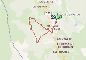

Length
7.2 km

Max alt
1741 m

Uphill gradient
390 m
Km-Effort
12.3 km

Min alt
1430 m

Downhill gradient
387 m
Boucle
Yes
Creation date :
2025-07-13 07:23:37.825
Updated on :
2025-07-13 10:37:36.352
3h13
Difficulty : Medium

FREE GPS app for hiking
 SityTrail
IGN / Geographical institutes
SityTrail Plus
The world is yours!
About
Trail Walking of 7.2 km to be discovered at Auvergne-Rhône-Alpes, Savoy, Les Allues. This trail is proposed by philcll.
Positioning
Country:
France
Region :
Auvergne-Rhône-Alpes
Department/Province :
Savoy
Municipality :
Les Allues
Location:
Unknown
Start:(Dec)
Start:(UTM)
309727 ; 5030435 (32T) N.
Comments